
Blog Post By Grant. To read Part 1, please check out our Blog/Home Page
It was late afternoon by now, but if we kept going at the same pace, there was enough time to finish the ride on dusk. This was reliant on a bit of luck, as a puncture or mechanical was not factored in to this.
Many of our bike rides after work end up riding into dimming light, so we we were comfortable with the situation, and we had some small lights as back up. So that was it, decision made. Basing the car in the middle of the route created a really useful stop off point. In readiness for G2 (the first half of the ride we nicknamed “G1”, the G coming from the name of our good friend Phil Gayes who showed us this route a few years ago), pockets were emptied of wrappers and filled with bars and gels. Bottles were refilled and we were set to go. Gunn Hill, here we come.
The climb of Gunn Hill has featured in the Tour of Britain on a number of occasions. It’s steep, but not particularly long. Today, we were riding it from the Meerbrook village side. The gradient gradually ramps up as you head into its tree shrouded beginning. The surface is pitted and tends to be damp. After the first steep section, a series of short steep ramps lead to the top. At this point the climb is more open, and your efforts are rewarded with views of rolling countryside, and hill tops clad in heather. There are times when the heather gives the hillsides in this area a fabulous purple glow. When this happens, it’s difficult not to spend time admiring the views and taking photos.
A place called Wincle comes next. It’s located within a narrow, wooded, steep sided valley. It’s home to a brewery, a pub and a couple of houses. I love passing through here, as it’s such a pretty place. I think the trees play a big part in this, deep green in Summer, golden brown in Autumn.
From here, the ride heads into rolling countryside. In the Spring the roads are frequently edged with flowers, and roadside fields are home to lambs and calves. In mid summer, the landscape takes on the deep green colour as the grass matures and provides grazing.
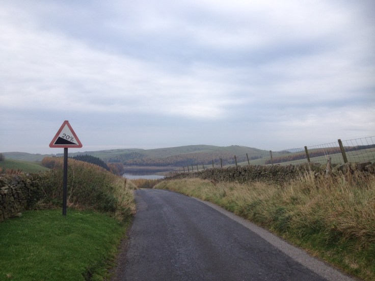
Our ride takes in a really steep climb which is placed right in the heart of this area. It quickly acquired the nickname of the “Tunnel of Terror”, as its sides are edged with stone walling, it has a gradient that touches 20%, and its summit is only visible when metres away. It’s mean!

Today, any personal goals specific to this climb were secondary to getting to the top with the least amount of effort. With the lowest gear selected, I worked my way up the steep, gritty Tarmac, frequently lifting from the saddle to soak up the steepest grades or to simply ease some of the strain on my legs. It’s rare to see any traffic on this piece of road, particularly during late afternoon, so I searched out any areas of slacker gradient or smoother road surface which appeared across its narrow width.
The top of the climb is rounded and at least one false summit builds a rider’s hope before the road flattens. A view of the moorland then appears, a mast highlights the Cat and Fiddle, with Macclesfield Forest spreading from the valley floor up the hillside. The forest is where our ride heads to from here. We head downhill to where the road into the forest begins.
The route contains many steep gritty, pitted descents, so it’s vital to keep your focus. On safely reaching the base of the descent, we take a sharp right, passing through a narrow street of cottages, before heading into the forest area. I really enjoy this part of the route. A blend of lakes, trees and hillside make it very picturesque. Seasonal colour changes prompt green to turn gold in the Autumn. I love the summer months, but frequently photograph this area later in the year, when it looks even more fabulous.
As I ride along the tree clad roads I take glances of the lakes/reservoirs dotted along the valley, but soon the road begins to climb very abruptly in front of me. This relatively narrow lane is known as The Standing Stone and it contains some short sections with gradients around 20%. My approach was similar, no heroics, just make it to the top with the least amount of effort. Even when ridden like this, the climb is a tough one, but it’s summit does represent the completion of the very steep ascents within our ride.
Emma arrived at the top of the climb soon after, and we chatted whilst polishing off another energy bar and sipping from our bottles. I think we were both quite pleased to have gotten over the last two climbs, and we were beginning to realise that the goal of completing the route was achievable.

It was now approaching early evening, and our surroundings were becoming quiet, as most people visiting the area had headed home long before. This is something I was really enjoying, and remarked to Emma that we may begin to adjust some of our rides to purposefully ride into dusk.
The next part of the route gradually climbs onto open, rolling moorland. When the road meets the top of each hillside, views across the Peak District stretch way into the distance. Part of what I love about riding in the hills and mountains is the elevation and space these environments provide.
The climbs remaining in the ride had reduced to a handful, and were generally longer, but less steep. The climb know as the Brickworks was next. We descended out of the hills, and skirted the edge of Pott Shrigley. There are some fabulous properties in this area, and I frequently admire the beautiful gardens and houses dotted along the road, approaching the Brickworks climb. A tricky right turn takes us to the start of the ascent. It is a relatively long climb for the area, and tends to be well known with local riders. I have witnessed a few contorted faces, along with Garmins bleeping, as a Strava related target is either achieved, or remains for another day.
Today, the Brickworks was empty of cyclists, and I aimed to keep a constant, steady rhythm to the top, using the first few low gears within the cassette to achieve this. At this point in the ride, my legs were feeling quite blunted by the amount of climbing we had done, and even though I had taken on food quite recently I realised that to keep going, more was needed. I used a little pull-in just after the summit to make a stop, meet with Emma and learn how she was feeling. It was good to hear that the Brickworks had gone well, and she was ready for the ascent of Pimm’s Chair. I took on half an energy bar, shoved what remained in my back pocket, and we set off again.
The descent to Kettleshulme, where the Pimm’s Chair climb begins, has a tree lined section close to the bottom, on a bend in the road. It’s quite possible to be carrying a little extra speed into this, so I always look out in case the surface is damp, offering a touch less grip. I passed through this shaded area of road, scrubbed off any momentum that remained from the descent, and clicked up the gears in readiness.
A tiny lane on the right is where our next challenge begins. Gaining height begins straight away, but the gradient remains relatively consistent throughout. We pass Windgather Rocks on our left, no climbers to be seen at this time of the day. I really enjoy riding this stretch of road, as it prompts fond memories of cycling in the Pyrenees, the surrounds of open farmland and narrow road creating subtle similarities.
The climb rewards with views across the moorland and valleys, contrasted by the rugged rock faces known as Pimm’s Chair. As the sun was now low, I was able to view the landscape lit in a softer light. This picked out different textures than the usual afternoon sunlight, and it felt a privilege to be cycling in the hills and taking in the views, unique to this evening.
We both took a moment to soak up the scenery before heading downhill, to one of my favourite areas, the Goyt Valley. For me, it’s the gradual climb from the valley floor that I really enjoy. The gradient is quite shallow, and I normally find it reasonably easy to climb and glance at the river, trees and heather clad hillside that all form part of this beautiful place. Small rock outcrops edge sections where the river has cut a little deeper, these too, make the valley such a wonderful place to cycle through.

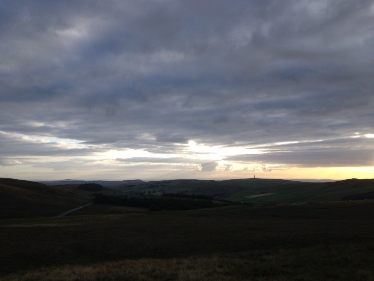
We rode most of the valley road together, enjoying the surrounds and chatting about the day. The vibe was good, and a fun descent awaited us at the top of the road out of the Goyt. On reaching the top of the valley, the sun was beginning to set. This gave some fabulous views over to the Cat and Fiddle mast and beyond. In the interest of making it up the final climb, I took on a caffeine energy gel, before setting off to complete the final piece of our challenge.
After a short stretch of relatively effortless pedalling, the road begins to truly descend. This piece of road is great fun, and other than brushing a little speed off for any of the curves, there is little to do other than hold on and enjoy the momentum. This combination of fabulous road, and spectacular sunset, certainly created a smile as I headed onwards.
The point where we leave this fast flowing road is initially highlighted by a slightly tighter left curve that is also a touch off-camber. This is a helpful prompt to ease the descending pace, in readiness for the relatively narrow lane we join next. This lane takes us into the rolling countryside which sits below Flash, the highest village in England. The road follows the edge of a hillside and undulates along its contours. As I have only pedalled occasionally whilst descending, any uphill in this road now feels a real shock to the legs! To create a distraction from this, I tried to spot the group of llamas which live in the field alongside the lane. I could make them out in the fading light, but had to resign myself that tired legs were not going to disappear any time soon.
Emma soon joined me and we prepared ourselves for the final climb, which places us at the back of the Roaches, a cluster of rocky outcrops and cliff faces, which is a real attraction for rock climbers. We found our own rhythm in the early steep section of the climb, but on the gradient levelling, the remaining few miles were pedalled together, sharing the enjoyment of achieving a goal we had set ourselves. We paused for a few minutes, looking down on the reservoir at Tittesworth, and took photos of the sun disappearing from the day.


After heading down the final, steep descent, I coasted up to the car and unclipped. It had been a fabulous day. 102 miles on the clock and approximately 13,000 feet of climbing. We finished right on dusk, and both agreed that more rides like this would definitely be in the pipeline.


Leave a comment